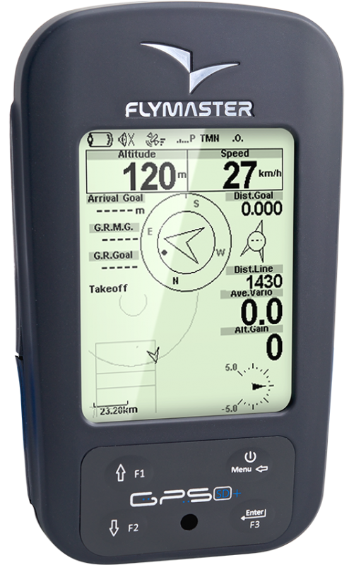
My Cart

Mini Cart

Flymaster GPS SD+
440.83
- +
Details

Don't get caught in airspace

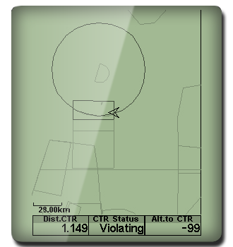
With Flymasters 3D airspace warning system you will have ample information to navigate around restriced airspace zones. 

Learn more about 


Know Where You Are

Flymaster SD series instruments have amazing worldwide road maps. Plan your flight and you'll never get lost.

Learn more about Maps


Design your own instrument

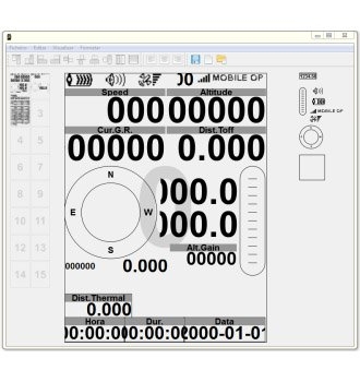
Need more or less data on your flight screens, with Flymasters' unique Designer you can create the instrument you like and need for your style of flying.

Learn more about 


Cloud Flights

With Designer app you can upload all your flights to our Cloud Flights Web Service. Inside your flight details page, you can review your flight, play it back, analyse all data, including all external sensors data, like G-forces and heart rate values. You can also download your flight in IGC format.

Learn more about 


Thermal efficiently

Flymasters' unique thermal ball will help you find the thermal core quicker and the zero buzzer make sure don't fly past lift.

Learn more about 


Expandable

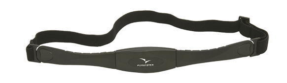
The GPS SD has a built in low power wireless interface for connecting compatible accessories. The list of Flymaster wireless accessories is the most complete on the market. Already available for the GPS SD are the HEART-G, TAS and M1.

Learn more about HEART-G and TAS


Flight Sharing

Leonardo Logo
XC Contest Logo

You can use GPSDUMP or any other compatible tool, for Flight Sharing. Just connect your GPS SD to your MAC / PC (windows) and with a few clicks you can download and share your flights, in several well known databases like Xcontest, Leonardo, or DHV.


So Easy

The Flymaster GPS SD implements an easy intuitive menu driven system with no need to memorise multiple functions on keys with long key presses.

Esay-To-Use Image
Technical Specs
More Information
Brand Flymaster
Specs

Main Hardware Characteristics


Display Resolution (High Contrast Grey Scale) 320x240 pixels
Screen size (true viewing area) 76x57 mm
Battery Capacity (Lithium-Ion) 4000 mAh
Autonomy  Approx. 35 hours
Size  155x92x24 mm (Length x Width x Thickness)
Weight  232 gr
GPS  50 channels/4hz
Native USB Connection  Allows connection to the PC to download/upload Flight Data, Airspaces Data, etc
Battery Charging From wall adapter, car adapter or standard usb port
Quad-band GSM GPRS class 10. Quad-band support: GSM 850 MHz, EGSM 900 MHz, DCS 1800 MHz and PCS 1900 MHz
RF Interface Allows the wireless connection of several external probes, like HEART-G or TAS probe, simultaneously
Micro SD slot Supports cards to 16 GB, Optional pre-loaded 16GB SD card with airspace, ground data and maps now available
6 Axis accelerometer and magnetometer Allows 6-degrees of freedom Tilt-compensated Compass (available soon)
Firmware update by USB (upgrades are free)

Interface Features


User definable pages (each page can be draw using designer software, and include a number of elements only limited by space) 16
Configurable graphical elements (depending of the element several parameters can be set by the user ex. Size, Border, …) 13
Configurable data field elements (User can change size, border, title, Font, ...)  61
Page Trigger Events (page switches automatically if a specific event occurs)
  • Airspace warning
  • Entering thermal
  • Transition (leaving thermal)
  • Arriving at turnpoint
  • Power up
Multi lingual interface
  • English
  • French
  • German
  • Spanish
  • Italian
  • Polish
  • Slovenian
  • Turkish
  • Portuguese
Configurable audible alerts
  • Airspace
  • Turnpoint complete
Definable function keys
  • Set Altimeter
  • Reset Altimeter 2
  • Task Navigator
  • Skip Waypoint
  • Set Volume
  • Near Airfields
  • Switch Page
  • Page Browser
  • Report Back

Variometer/Altimeter Features


  • Buzzer/near thermal sound
  • Ultra sensitive Variometer with 10 readings per second and 10 cm resolution
  • Configurable vario digital filter and integration values
  • Fully configurable Vario Sound (frequency, increments, frequency/vertical speed relation,….)
  • 6 Sound Levels (configurable by menu, or using a key)
  • Automatic mute, keeps vario silent until takeoff
  • Altitude adjustment using QNH
  • Automatic altitude adjustment from GPS
  • 3 independent altimeters

Memory Features


  • 3D flight logger IGC format
  • Storage for >300000 track points
  • Up to 248 flights
  • 448 Waypoints

3D Airspace


  • Compatibility with Open Air format (upload of files using Designer)
  • Display of restricted areas in map
  • Adjustable warning vertical distance to a restriced area
  • Adjustable warning horizontal distance to a restriced area
  • Display of shortest Vertical, and Horizontal, distance to restricted area
  • Resctrited area alarms (Altitude imminent, Position imminent, Violation, …)
  • Critical Airspace page (displays information about areas that are closer than a defined distance)
  • Worldwide Airspace database (SD card required) ( ).

Cross Country Features


  • Exclusive Thermal Ball indicator
  • Several specific data fileds like Distance to take off, current and avarage glide ratio, avarage speed, etc.
  • Distance to last thermal indexed with altitude
  • Goto waypoint
  • Multiple waypoint route
  • Wind Speed and Direction (GPS based calculations)
  • Automatic altitude gain profiler
  • McCready related values like speed to fly, next termal climb, etc. (available with the TASProbe)
  • Nearby Landings (Displays Required Glide Ratio and distance to all the Landings which can be reached)

Route Features


  • Arriving altitude at next waypoint
  • Several Glides Ratios (average, to waypoint,…)
  • Easy route definition
  • Task Navigation, configurable safety/risk margin on turn points.
  • Map (trace with thermal indication)

Live Tracking


  • Upload of flight data to repositories using the GSM network (compatible with several repositories like Leonardo XC server, XContest, DHV)
  • Automatic almost real time flight data sending to a remote live tracking server through GSM network. (compatible with several servers like Flymaster, LiveTracking24, DHV, etc)
  • On demand sending of Predefined messages to a server (eg. Need Assistance, Need Retrieval, etc)
  • Automatic data receiving from a remote server like alarm messages, task definition, etc.
  • Periodic sending of SMS with position to a predefined number
  • Event triggered sending of SMS with position to a predefined number
  • Small GPRS data usage (considering that communication is not lost, in average, requires 25KB per flight/hour).

Interfacing


Compatible with MacOS (10.13 and higher), Windows (7/8/10)

Instrument Type Vario + GPS
Availability
1-4 weeks